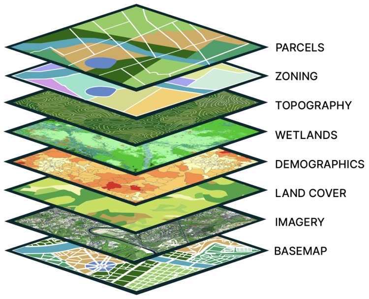
Al Muriyat Al Mutakamilah helps organisations optimize operations, improve efficiency, and achieve sustainable growth through GIS, CAD/BIM, digital engineering, and enterprise technology solutions.
We deliver engineering, digital, and enterprise technology services across the region, helping public and private organisations turn complex infrastructure data into clear, usable intelligence.
With regional experience across Oman, Bahrain, and Kuwait, our work is grounded in global GIS, CAD, and digital engineering standards, then tailored to the realities of local projects, teams, and assets.
From consulting and implementation to field data and enterprise automation, our services help organisations manage infrastructure information with accuracy and confidence.
CAD/BIM solutions, engineering software implementation, digital transformation consulting, and project lifecycle management.
Learn MoreSoftware integration, data management systems, process automation, and cloud collaboration platforms for connected teams.
Learn MoreArcGIS-powered mapping, spatial analytics, web dashboards, mobile field collection, and CAD-to-GIS migration.
Learn MoreWe connect maps, models, assets, field teams, and enterprise data so decision-makers see the full picture.
Centralized GIS platforms for infrastructure mapping, utility networks, facilities, dashboards, and spatial analysis.
Discover GISConvert design data into reliable spatial intelligence and digital-twin foundations for planning and operations.
Explore IntegrationDashboards and mobile GIS applications that bring live project, asset, and field data to the people who need it.
View DashboardsWe combine practical regional knowledge with the technical discipline needed for large-scale infrastructure programmes.
Experience across Oman, Bahrain, and Kuwait in infrastructure, planning, and digital engineering.
GIS, CAD, BIM, field data, and enterprise systems connected into one dependable workflow.
Knowledge shaped by smart campuses, industrial areas, utilities, facilities, and urban analysis.
Clear documentation, accurate spatial data, and solutions designed to support long-term decisions.
Talk to Al Muriyat about GIS, CAD/BIM, enterprise IT, or a complete digital transformation roadmap.